NEGOTIATIONS AFFAIRS DEPARTMENT - 21 DECEMBER 2006
SPECIAL REPORT
GHETTOIZATION OF A NATION:
FOCUS ON LAND CONFISCATION IN THE WESTERN BETHLEHEM GOVERNORATE
On the eve of Christmas celebrations throughout the world, pilgrims travelling to Bethlehem will encounter an intricate maze of Israeli walls, tunnels, checkpoints and settlements before reaching their final destination. Over the past 2 years, the Bethlehem Governorate has been the target of increased land confiscation by the Israeli military in order to implement a systematic policy of segregating Palestinian communities from illegal Israeli settlers and colonising Palestinian land in the Occupied Palestinian Territory.
Since January 2005, over 2,400 dunums (600 acres) of land have been confiscated in the Bethlehem Governorate for construction of the Wall, establishing Israeli settleronly bypass roads and underpasses for Palestinian traffic, checkpoint terminals, and the ongoing expansion of illegal Israeli settlements. As a result, the Bethlehem Governorate has been transformed into a series of ghettos – Palestinian population centres are isolated and the socio-economic well-being of over 180,000 Palestinians living in the area is impaired.
In particular, the western Bethlehem Governorate has become increasingly smaller for its Palestinian residents due to the existence of the Etzion “bloc”, an ever-expanding area of Israeli settlements located west of the approved Wall route. In order to strengthen the Etzion bloc and facilitate its future expansion, large swathes of Palestinian land have been confiscated to create settler only bypass roads that link settlements to each other, to Israel, and to Jerusalem. In addition, a series of underpasses and checkpoint terminals to divert Palestinian traffic away from these areas are being constructed.
This Special Report surveys recent Israeli land confiscation in the western Bethlehem
Governorate and construction currently underway on various aspects of Israel’s settlement infrastructure, including the Wall, checkpoint terminals, bypass roads and the settlements themselves. The report is based on Israeli-issued military orders and field data collected by the PMG.
Wall Construction
In March 2006, Israel completed the final section of the Wall that effectively separates Bethlehem from Occupied East Jerusalem, severing the historic connection between the region’s holy sites. Incorporated into the Wall, Rachel's Tomb/Bilal bin Rabah Mosque, a Bethlehem shrine holy to Muslims and Jews, is barred to all Palestinians. The area around the Tomb/Mosque and the road leading to the city’s holy sites, including the Church of the Nativity, has seen the majority of businesses close since the beginning of Wall construction, decimating a once thriving economic area. The Wall penetrates 1 ½ kilometres (km) inside the boundaries of the Bethlehem Governorate and confiscates 3km2 of its land.
Shortly after completing this portion of the Wall, on 30 April 2006, the Israeli government approved several changes to the Wall route. However, the changes incorporated into the new Wall route mean very little on the ground – 80 percent of the Wall continues to be routed on Palestinian territory, de facto annexing 9.0 percent of the West Bank, and usurping valuable agricultural and water resources sustaining the Palestinian community. In some areas, the Wall has been rerouted to effectively annex even greater amounts of Palestinian land than the previous route.
In the western Bethlehem Governorate, the two most significant changes to the Wall route include the creation of a walled enclave in Al Walaja, separating village residents from their agricultural land, and the incorporation of the village of Al Jaba’ into the area between the Wall and the 1967 border, making it one of several Palestinian villages isolated from the rest of the Bethlehem Governorate and surrounded by ever expanding settlements in the Etzion settlement bloc.
In the past 2 years, the Israeli army has issued military orders confiscating over 1,800 dunums (450 acres) of land for construction of the Wall in the western Bethlehem Governorate. The military orders listed below reflect only a portion of land confiscation for Wall construction in the western Bethlehem Governorate that has resulted in the creation of the ‘Bethlehem ghettos’. Upon completion of the Wall, the incorporation of the Etzion settlement bloc will de facto annex the western Bethlehem Governorate to Israel, severing the governorate into eastern and western ghettos. This falls in line with Israel’s attempt to integrate the Etzion bloc into “Greater Jerusalem”, an Israeli term designating the unilateral expansion of the city’s boundaries through the inclusion of a ring of settlements located within the West Bank. As a result, Palestinian villages and land to the west of the Wall in the Etzion settlement bloc will be isolated, including 73 km2 of land belonging to the Bethlehem Governorate, and Palestinian access restricted.
The Bethlehem Governorate will further be divided into northern and southern ghettos by Israeli settler bypass roads, tunnels and settlements.
On 4 September 2006, the Israeli army issued Military Order # T/77/06, confiscating 102.2 dunums (25.55 acres) from the villages of Irtas and Al Khadr for construction of the Wall. The affected land extends from the village of Al Khadr along Road #60 and snakes towards the area of Khirbet ‘Ilayya southwest of the village of Irtas. Wall construction in this area reflects the changes to the Wall route since 30 April 2006, moving the Wall eastwards nearer Palestinian civilian houses. This Wall section will also annex the area of Khirbet ‘Ilayya to the western Wall ‘buffer zone’ and prevent Palestinian civilians from accessing Road #60.
On 5 September 2006, the Israeli army issued Military Order No. T/69/06 confiscating 152 dunums (38 acres) of land belonging to the town of Beit Ummar in the governorate of Hebron as well as the villages of Beit Fajjar and Al Khadr in the Bethlehem Governorate. The confiscated land will be used for Wall construction in addition to construction of an underpass in the area of Um Salamuna, south of the city of Bethlehem (see section below). Land levelling for the Wall in this area is currently underway in Jurat ash Shama’a and Wadi Rahhal, but construction of the underpass has not yet begun.
In order to incorporate the village of Al Jaba’ into the Wall surrounding the Etzion bloc, the Israeli army issued Military Order #T/33/06 on 15 May 2006, confiscating 30.34 dunums (7.585 acres) of land from the village of Al Jaba’. When completed, the Wall will isolate the village of Al Jaba’, along with several other Palestinian communities in the western Bethlehem Governorate – Battir, Husan, Wadi Fukin, Nahhalin, Khallet Sakariya, Khallet al Balluta and Khallet al Afana – inside the Walled Etzion bloc and separate them from the eastern Bethlehem Governorate.
While Wall construction in the area has not yet begun, land levelling is currently underway for the creation of the new Al Jaba’ checkpoint terminal.
On 19 February 2006, the Israeli army issued a border modification to Military Order # T/86/05, originally issued on 01 May 2005, increasing the amount of land confiscated from the villages of Al Walaja, Battir, Husan, Al Qibya, Wadi Fuqin and Surif, from 756.5 dunums (189.13 acres) to 766.6 dunums (191.65 acres). The order is for construction of the Wall extending from the village of Al Walaja southwest towards the village of Husan, above the Israeli settlement of Betar Ilit. The revised military order significantly moves the Wall path westwards, incorporating more land belonging to the villages of Husan and Battir.
On 02 November 2005, the Israeli army issued Military Order # T/201/05, confiscating 94.3 dunums (23.58 acres) of land from the city of Beit Jala and the village of Al Khadr for construction of the Wall along Road #60. Land levelling for construction of the Wall in this area was begun in February 2006, and will encompass a length of 2.465 km and a width ranging between 14 to 27 meters. In addition to the concrete portions of the Wall currently under construction, portions consisting of 7- meter high chain-link fence have been completed around the town of Al Khadr, extending from the south-western entrance of the town to its north-western entrance, where an Israeli watchtower has also been erected.

Completed Wall at the entrance to the village of Al Khadr along Road #60. An underpass connecting Al Khadr and the eastern Bethlehem Governorate to the western Bethlehem Governorate will be located approximately 500 meters south of this area along Road #60.

Immediately to the north of the constructed Wall in Al Khadr is the newly expanded Tunnels Road checkpoint, leading to Jerusalem.
Checkpoint Terminals, “Crossings”, and Tunnel Construction
The creation of new checkpoint terminals, “crossings”,1 and tunnels is an integral component of Israel’s settlement infrastructure and plans to fragment and isolate Palestinian communities. Forming a key part of the Wall regime, the establishment of these structures constitute points of control for access into and out of Palestinian ghettos, creating de facto walls between Palestinian communities within the Occupied Palestinian Territory and restricting Palestinian access to agricultural lands. A number of these checkpoint terminals are located in the Bethlehem Governorate on Occupied Palestinian Territory.
The Bethlehem/Rachel’s Tomb checkpoint terminal (formerly Checkpoint 300), at the northern entrance to the city of Bethlehem, became operational on 15 November 2005. The terminal restricts access to Occupied East Jerusalem from the Bethlehem area, with crossing permitted only to foreign nationals, Palestinians holding Jerusalem IDs and Palestinian civilians from the West Bank with permits from the Israeli military. 2
To the east of the city of Bethlehem lies the Mazmuriya checkpoint terminal, currently under construction in the area of Khallet an Nu’man. The checkpoint is intended to become a commercial terminal linking the southern and northern governorates of the West Bank.
Al Jaba’ checkpoint terminal, located southwest of the city of Bethlehem and in the north-western Hebron Governorate, has been under construction since the beginning of 2005 on land confiscated from the villages of Al Jaba’ and Surif. Issued on 4 September 2005, Military Order # T/158/05 confiscated 110 dunums (27.5 acres) of land for construction of the terminal. The revised Wall route, approved 30 April 2006, places the village of Al Jaba’ between the Wall and the 1967 border, annexing the area to the Etzion bloc. The existing Al Jaba’ checkpoint, leading to areas in Israel, will be replaced by the new terminal and become part of the Wall infrastructure, as the Wall extends eastwards from the terminal. According to the Israeli Ministry of Defence website, the terminal is to include a crossing point for residents of Al Jaba’ to access the town of Surif on the other side of the Wall.3
Al Khadr “crossing”, west of the city of Bethlehem, is also currently under construction. On 21 November 2005, the Israeli army issued Military Order # T/210/05, confiscating 85 dunums (21.25 acres) of land from the villages of Al Khadr and Battir and the city of Beit Jala for the establishment of the crossing. Plans for the “crossing” include a tunnel stretching under Road #60, which will serve as the only access point between the villages of the western Bethlehem Governorate (including Battir, Husan, Nahhalin, Al Jaba’, Wadi Fukin and Khallet Zakariya), which will be isolated west of the Wall, to the village of Al Khadr and other parts of the Bethlehem Governorate located east of the Wall. Construction works are currently underway for this underpass on both sides of Road #60.

Construction work on the Al Khadr underpass, east of Road #60, with the village of Al Khadr in the background. Land levelling and digging have commenced for the underpass on both sides of Road #60.
On 19 February 2006, the Israeli army issued Military Order # T/25/06, confiscating 39.8 dunums (9.95 acres) of land from the city of Beit Jala and the village of Al Walaja for construction of the Walaja/Har Gilo “crossing”, north-west of the city of Bethlehem. Military Order T/24/06, confiscating 170 dunums (42.5 acres) of land from the city of Beit Jala and the village of Al Khadr, is also designated for the Walaja “crossing” and a road running from nearby Har Gilo settlement to Road #60. The road will run adjacent to the existing Palestinian road connecting the town of Al Khadr to the city of Beit Jala and the village of Al Walaja, and is expected to be a settler only bypass road connecting to Road #60. Al Walaja “crossing” will be the only access point for residents of Al Walaja to other areas in the Bethlehem Governorate, controlling movement into and out of the village. Upon completion of the road and terminal, it is expected that Palestinian traffic will be allowed only on the existing Palestinian road, and diverted under Road #60 through the Khadr underpass. Land levelling for construction of the road is currently underway below the settlement of Har Gilo, and road pavement and traffic changes have begun near the Road #60 intersection to Beit Jala.
On 9 July 2006, the Israeli army issued Military Order # T/69/06 confiscating 152 dunums (38 acres) of land from the villages of Beit Ummar, Beit Fajjar and Al Khadr for construction of the Wall and the Um Salamuna “crossing”, south-east of the city of Bethlehem. The confiscated land stretches over a length of 1.795 km and a width of 100 meters. Land levelling and uprooting of trees has begun in the area of Um Salamuna, Jurat ash Shama’a, and Wadi An Niss for implementation of the order. The Um Salamuna “crossing” will include an underpass under the existing Israeli settler bypass Road #3157, which divides the eastern Bethlehem Governorate into northern and southern areas, and connects to bypass Road #356 northwards through Khallet Beit Zakariya, Al Fureidis, Za’atara, Beit Ta’mir, Khallet Nu’man and Khallet al Khas. The Um Salamuna “crossing” will be the only access point for Palestinian residents in the area north of bypass Road #3157 to the area south of the road. As such, the eastern Bethlehem Governorate will be encircled by Israeli settler bypass roads as well, which will isolate the area in a manner similar to that of the Wall. At present, land levelling for the Wall in this area is underway; however construction of the “crossing” has not yet begun.
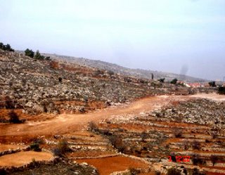
Land levelled in Jorat ash Shama’a and Um Salamuna for construction of the Wall, which will incorporate the settlement of Efrata to the East, pictured in the background.

View of the area designated for the Um Salamuna terminal, taken from Road #3157, under which the tunnel is expected to pass. The settlement of Efrata is to the east.
Ghettoizing Palestinian Communities to Expand Israeli Settlements
Israeli land confiscation in the western Bethlehem Governorate reflects Israel’s desire to strengthen illegal Israeli settlements on Occupied Palestinian Territory and facilitate their expansion. Along with East Jerusalem and the governorates of Salfit and Qalqiliya, the Bethlehem Governorate is one of the most heavily concentrated areas of Israeli settlements in the West Bank. The Etzion bloc alone is comprised of 12 settlements – Betar Ilit, Har Betar, Har Gilo, Nahal-Geva’ot, Neve Daniyyel, Rosh Tzurim, Elazar, Efrata, Bat Ayin, Allon Shevut, Kefar Etzion, and Migdal Oz. These settlements, including a population of roughly 45,000 Israeli settlers, are located on an area encompassing nearly half the Bethlehem Governorate to the west. The Etzion bloc, and the Wall and associated infrastructure being constructed around it, threaten to eliminate the presence of a Palestinian population of approximately 20,0004 residents in the western Bethlehem Governorate who will be isolated into ghettos west of the Wall. Betar Ilit, constructed on land belonging to the villages of Husan and Wadi Fukin, is one of the most rapidly expanding Israeli settlements in the West Bank. In May 2006, Israeli Defence Minister Amir Peretz approved the expansion of the jurisdictional areas of four West Bank settlements, including 500 additional dunums (125 acres) for the settlement of Betar Ilit, bringing it closer to Jerusalem. In 2005, the Israeli authorities issued tenders for 222 new housing units in the settlement, and in 2006, an additional 342 tenders were issued. Expansion works, including land levelling and construction of housing units, are currently taking place at a rapid pace.

Northwest expansion of Betar Ilit settlement, located southwest of Wadi Fukin. Expansion work includes construction of new housing units and land levelling below for construction of a ‘security wall’.
Land cultivated by Palestinians in the environs of these illegal settlements is subject to regular attacks by Israeli settlers. In the past year alone, Israeli settlers have set fire to Palestinian land in the area; uprooted olive trees; thrown stones and opened fire towards farmers; and seized control of and cultivated Palestinian land. Sewage waste is often dumped from these settlements onto Palestinian agricultural lands, contaminating crops and trees cultivated in the area. The settlement of Betar Ilit, for example, regularly discharges waste water onto agricultural lands belonging to the village of Wadi Fukin.
Residents also report that on Fridays, the filters of the sewage pumps are turned off for 24 hours, creating an environmental hazard and threatening land cultivated with vegetables, plum and olive trees, and grapevines, and contaminating natural springs in the village used to irrigate crops. Palestinian farmers attempting to harvest their crops in the area of the settlement report that they are also regularly harassed by Israeli settlers and forced from their lands.
The construction of the Wall and other settlement infrastructure serve to safeguard the
future of the Israeli settler population and de facto annex vast areas of Palestinian land to Israel at the expense of the indigenous Palestinian population. Settler bypass roads connecting settlements to each other, to Israel, and to Occupied East Jerusalem sever Palestinian contiguity and seize Palestinian land to create new access roads for settlers.
At the same time, Palestinian traffic is diverted away from roads used by Israeli settlers through a series of underpasses and secondary roads constructed on confiscated Palestinian land. Rather than facilitating access to Palestinian communities and land isolated by the Wall and settlement construction, these diversions create yet more barriers to Palestinian life and threaten to destroy an already devastated community. The combination of these unilateral Israeli measures facilitates Israeli settler mobility, growth and development, while ghettoizing a nation of Palestinians into rapidly unsustainable and shrinking communities.
1 The term used in official Arabic translations of Israeli military orders to refer to these terminals is “ma’bar”, literally meaning ‘crossing’. Due to the ambiguity of the term, it is difficult to ascertain whether the ‘ma’bar’ will be an Israeli controlled checkpoint, a tunnel, or a larger checkpoint terminal. The size and nature of these structures is usually unclear until construction is underway or completed. For the purposes of this report, where it is unclear from the military order what the nature of the structure will be, the term ‘crossing’ is used.
2 For more information on procedures at the Bethlehem checkpoint terminal, see the PMG Special Report New Bethlehem Checkpoint Terminal: Israeli Unilateralism in the Occupied West Bank, 01 December 2005. For more information on checkpoint terminals throughout the West Bank, see the PMG Special Report Status of Construction: Israeli Checkpoint Terminals, 14 December 2006. Both reports are available
at: http://www.nad-plo.org/main.php?view=pmg_special/.
3 See http://www.securityfence.mod.gov.il/Pages/ENG/news.htm#news45/.
4 Palestinian Central Bureau of Statistics, 2006 Mid-Year Projections.
posted by Ruy Filho at
2:28 PM
![]()
![]()
0 Comments:
Postar um comentário
<< Home